Pathfinder has expanded the known global pit-constrained resources to over 716 Million tons of Measured and Indicated Resources, including both supergene and hypogene material, with average grades of 0.058% Mo and 0.088% Cu, as well as over 149 Million tons of Inferred Resources averaging 0.041% Mo and 0.072% Cu. The supergene copper-focused resources total more than 138 Million tons of Measured and Indicated Resources averaging 0.269% Cu and 0.036% Mo, or Copper Equivalent of 0.41%.
In addition to the resources identified in the 2024 Mineral Resource Estimate, Cu-Mo porphyry mineralization is known to be present to the east of the Hall Stock, and at depth. There is also potential for identification of additional supergene resources to the north and south of the known supergene blanket.
Pathfinder’s land package contains several historic mines, primarily active between 1854 and the early 1900s during the development of the Tonopah silver district. Historic production from these mines was dominantly silver and includes extraction at the Liberty mine (with a four-stamp mill and smelter), the Spanish mine and the Florence mine.
The Tonopah district produced more than five million tons of silver-dominated ore in the early 1900s through companies like Tonopah-Belmont Mining that operated a 60-stamp mill. The Tonopah silver strike discovery is second only to the Comstock Lode in Nevada.
Silver targets within Pathfinder’s land package remain largely un-tested. Surface sampling from vein material at the historic Liberty mine showed results of over 795 ppm Ag and over 459 ppm Ag at the Florence prospect. Other prospects around the property have not yet been sampled, nor have any of them been tested with drilling. Mineralized structures at Florence and Liberty appear to strike into and cross-cut porphyry mineralization in the porphyry Mo/Cu resources. Metal ratios and cross-cutting relationships suggest silver mineralization in these peripheral prospects is different than porphyry mineralization and likely to be related to the silver mineralization in the Tonopah district.
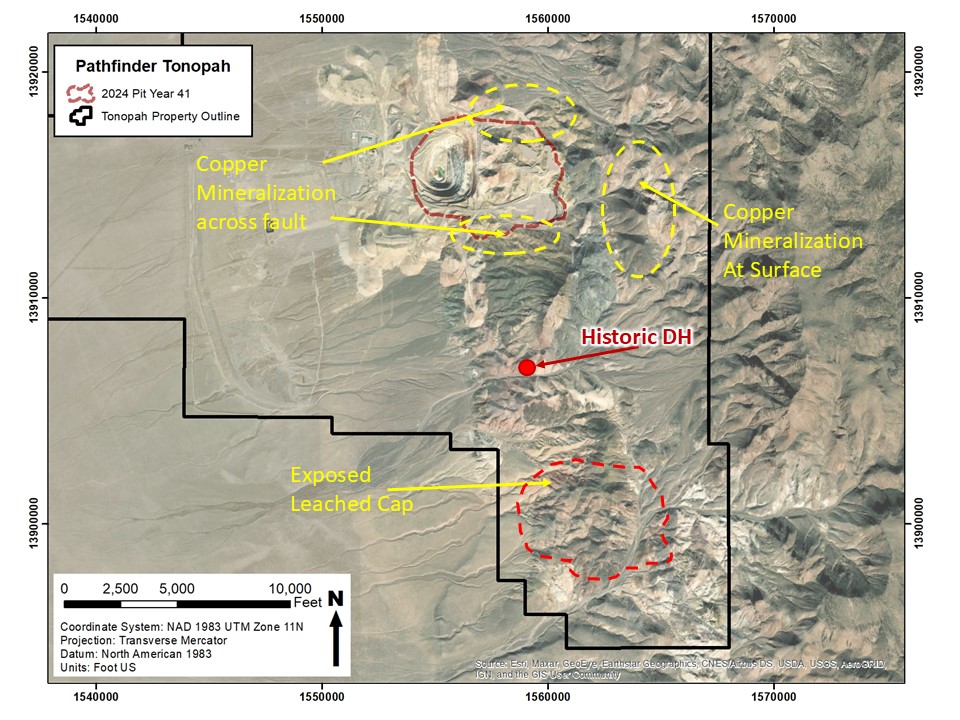
South of the known porphyry resources, there is evidence to suggest other porphyry centers. Approximately 1.7 miles to the south of the existing pits, a historic exploration hole intercepted altered meta-sediments and quartz monzonite with molybdenum mineralization at depth. Further south, limited surface reconnaissance found evidence of what has been interpreted as potentially a leached cap of a porphyry system with a footprint of similar size to that at the known resources. Some historic surface disturbances in the vicinity appear to be old drill pads where historic documents suggest Phelps Dodge drill-tested for porphyry mineralization.
The property has great exploration potential for high-grade silver mineralization and other porphyry centers, all within our current package of private land and unpatented claims.
NW-SE Cross section looking north containing PD22-869. Copper-dominated intercepts are shown in red blocks on the right-hand side of the drill trace, and molybdenum-dominated intercepts are shown in blue blocks generally on the left side of the drill trace.
WNW-ESE Cross section looking east containing PD22-872, drilled in 2022. Copper-dominated intercepts are shown in red blocks on the right-hand side of the drill trace, and molybdenum-dominated intercepts are shown in blue blocks generally on the left side of the drill trace with composited assay results shown from 2022 drilling. PD22-873 is also shown in this section. Note strong molybdenum mineralization identified well below the limits of the Resource pit.
NW-SE Cross Section looking northeast containing PD22-874. Well mineralized copper intercepts are shown in red blocks on the right and blue blocks on the left side of the drill trace show moly mineralization. Again, note mineralization well below and at the base of the Resource pit.
NW-SE Cross section looking northeast containing PD22-877. Well mineralized copper intercepts are shown in red on the right and blue blocks on the left side of the drill trace show moly mineralization. The green interval is a thick intercept of andesite.